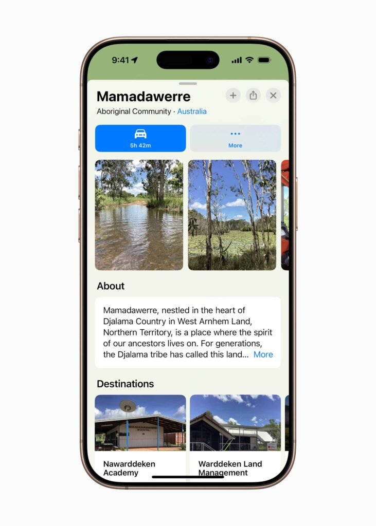
If you open Apple Maps today, you’ll notice something a little different. It now displays Indigenous lands in Australia and Aotearoa New Zealand. It’s not complete, in fact there’s a long way to go, but it’s a start. As a Kamilaroi Man I appreciate the delicate way that Apple has gone about this project. Nothing is more sacred than connection to country.
Apple uses language data published by the Australian Institute of Aboriginal and Torres Strait Islander Studies (AIATSIS) combined with information from local language holders, language centres, Aboriginal Land Trusts, and ranger groups. It then shows up as faint overlay that’s rendered in a very light plum colour. When you zoom you can click on the location for more information.

“Sharing our story and deep connection to the land is a meaningful moment for our community — a testament to our resilince, history, and vision for the future,” said Rodriguez Pindiying, a community member from Mamadawerre.
“This isn’t just about geography; it’s about preserving our culture and ensuring Mamadawerre’s legacy for generations. Through Apple, we have the rare privilege of sharing our heritage on a global stage, reminding the world that no matter how distant we may seem, our connection to the land, to each other, and to the world is universal.”

Apple Maps show reserves and Indigenous Protected Areas, Indigenous place names, Traditional Country, and dual-language labels. Indigenous lands place cards feature information about the local area and Traditional Owners. Communities can add their own photos, destinations on their land, and text in their own language.
The beauty of MapKit is its ability to expand into the whole Apple experience. Indigenous lands will now show up in apps like Weather and Find My, as well as in third-party apps that use MapKit.


In New Zealand, Apple worked closely with Indigenous cartographers and several Māori tribes (iwi).
“For Tūhourangi, this partnership with Apple Maps is more than just a technological collaboration — it reflects our role as kaitiaki (caretakers), ensuring the protection and accurate representation of our cultural heritage,” said Annie Balle from Tūhourangi iwi.
“By bringing our stories to a global audience, we can uphold our narratives, safeguard our data sovereignty, and demonstrate how Indigenous knowledge and technology can work together to promote cultural understanding and sustainability.”
Apple can be an easy target due to its size and status in the tech industry but I must admit the company actually does a lot of good for the community without much credit. For example. this week Apple announced it will collaborate with communities to advance technology’s role in preserving culture and enhancing education. Aside from Apple Maps representation there are new community grants for local partners, and an expansion of the Apple Foundation Program, which helps students pursue careers in the app economy.

“We’ve had teams in Australia and New Zealand for over 40 years, and we’re thrilled to deepen our relationships here and bring new opportunities to communities across both countries,” said Alisha Johnson Wilder, Apple’s senior director of Environment, Policy, and Social Initiatives.
“These efforts put community first by representing Indigenous land, expanding access to education, and protecting our shared environment.”


